Weather Station Location and Geographical Setting
The weather
station I chose is the Honolulu International Airport station located in
Honolulu, Hawaii. Hawaii is located in the Pacific Ocean just west of the
United States and south of the Tropic of Cancer. Therefore, Hawaii is located
in the tropics with a maritime climate (NOAA, 2016). As well, since Hawaii is
located between the Tropic of Cancer and the equator it receives northeast
trade winds. In terms of Honolulu, it is located on the southeast coast
of the third largest Hawaiian Island called Oahu (City-Data, n.d.).
 |
| Here is a broad map that shows the location of Hawaii in the Pacific Ocean. As well, in this image it shows that Hawaii is right under the Tropic of Cancer. Source: http://www.worldatlas.com/na/us/hi/where-is-honolulu.html |
 |
| The red outline depicts the area and location of Honolulu in Oahu. Source: https://www.google.com/maps/place/Honolulu,+HI/ |
 |
| The red circle on the map indicates where the Honolulu International Airport weather station is located in Honolulu. Source: https://www.ncdc.noaa.gov/cdo-web/datatools/findstation |
Aside from the Pacific Ocean being a large geographical aspect of Honolulu, there are other beautiful and historical geographical aspects.
One other large geographical aspect in Honolulu is the Ko'olau Mountain, which dominates the east
side of Oahu (Woods, n.d.). In particular, Honolulu is located on the leeward
side of the mountain, which causes it to receive warm air. There are also two
craters located in Honolulu which is the Punchbowl Crater and the Diamond Head
crater that both formed after a volcanic eruption (Woods, n.d.).
 |
| The red navigation point on the map depicts the mid-point of the Ko'olau Mountain. As you can see, the Ko'olau Mountain dominates the entire east side of Oahu, and Honolulu is located near the southeast end of the mountain. Source: https://www.google.com/maps/place/Ko%CA%BBolau+Range/ |
 |
The red navigation point shows where the Punchbowl Crater is located. The Diamond Head is the green circle located in the lower right-hand corner of the map.
Source: https://www.google.com/maps/place/Punchbowl+Crater/ |
Average Monthly Temperatures
Honolulu
contains warm temperatures all year
round (NOAA, 2016) because it’s
located in the tropics and receives northeast trade winds. The average monthly
high's from 1960-2016 ranges from 80.0 ˚F to 88.6 ˚F, with the
highest temperature occurring in July and the lowest in December. On the other
hand, the average monthly low’s
ranges from 66.0 ˚F to 74.8 ˚F with the highest temperature occurring
in August and the lowest in January. Honolulu
is known to have only 2 seasons with very little temperature differences, which is
summer (May to October) and winter (October to April) (NOAA, 2016). In general, Honolulu experiences
higher temperatures during the summer and lower temperatures during the winter as
depicted in the graph below. |
| Average monthly temperature for Honolulu during 1960-2016. Data Source: Lawrimore, Jay (2016). Global Summary of the Month, Version 1.0. [Honolulu International Airport, HI US].NOAA National Centers for Environmental Information. DOI:10.7289/V5QV3JJ5 [February 27, 2017]. |
 |
| Graphical representation of the average monthly temperatures. Data Source: Lawrimore, Jay (2016). Global Summary of the Month, Version 1.0. [Honolulu International Airport, HI US].NOAA National Centers for Environmental Information. DOI:10.7289/V5QV3JJ5 [February 27, 2017]. |
Average Monthly Precipitation
Honolulu generally receives very little precipitation all
year round. The average monthly precipitation during 1960-2016 ranges from 0.4
to 3.1 inches. The highest average monthly precipitation is in the month of
December, and the lowest is in the month June. When the average monthly
precipitation and the overall average monthly temperatures are graphed
together, they have an inverse relationship. In other words, the hot summer
months receives less moisture compared to the warm winter months.
 |
| Average annual precipitation of Honolulu from 1960-2016. Data Source: Lawrimore, Jay (2016). Global Summary of the Month, Version 1.0. [Honolulu International Airport, HI US].NOAA National Centers for Environmental Information. DOI:10.7289/V5QV3JJ5 [February 27, 2017]. |
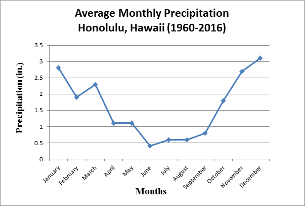 |
| Graphical representation of the average monthly precipitation from 1960-2016. Data Source: Lawrimore, Jay (2016). Global Summary of the Month, Version 1.0. [Honolulu International Airport, HI US].NOAA National Centers for Environmental Information. DOI:10.7289/V5QV3JJ5 [February 27, 2017]. |
 |
| This graph shows the relationship between the overall average monthly temperatures and average monthly precipitations from 1960-2016. Data Source: Lawrimore, Jay (2016). Global Summary of the Month, Version 1.0. [Honolulu International Airport, HI US].NOAA National Centers for Environmental Information. DOI:10.7289/V5QV3JJ5 [February 27, 2017]. |
Bowen Ratio Guestimate
The Bowen Ratio (BR) tends to be higher in dry regions
compared to moist regions. In the case of the Honolulu, it’s a relatively moist/humid
region due to the Pacific Ocean supplying moisture into the air (NOAA, 2016).
In 2014 the monthly relative humidity ranged from 0.6816-0.7188 which is
moderately high (Giambelluca, 2014). As well in 2014, the latent heat flux in
Honolulu ranged from 6.736 W/m² - 8.358 W/m². In
general, Honolulu's latent heat exchange is likely to be higher than the
sensible heat exchange due to its humidity. Since the latent heat will be
higher than the sensible heat, the BR for Honolulu will be less than 1 and even
perhaps lower than 0.50.
 |
| The graph on the left shows the monthly relative humidity of Honolulu International Airport in 2014. The image on the right shows the annual relative humidity of the Oahu as a whole in 2014. Source: http://climate.geography.hawaii.edu/interactivemap.html |
 |
The graph shows the monthly latent heat flux of Honolulu International Airport in 2014. The map on the right shows the annual latent heat flux of Oahu as a whole in 2014.
Source: http://climate.geography.hawaii.edu/interactivemap.html |
- City-Data. (2017). Honolulu: Geography and Climate. Retrieved from http://www.city-data.com/us-cities/The-West/Honolulu-Geography-and-Climate.html
- Giambelluca, T.W., X. Shuai, M.L. Barnes, R.J. Alliss, R.J. Longman, T. Miura, Q. Chen, A.G. Frazier, R.G. Mudd, L. Cuo, and A.D. Businger. (2014). Evapotranspiration of Hawai‘i. Final report submitted to the U.S. Army Corps of Engineers—Honolulu District, and the Commission on Water Resource Management, State of Hawai‘i.
- Lawrimore, Jay (2016). Global Summary of the Month, Version 1.0. [Honolulu International Airport, HI US].NOAA National Centers for Environmental Information. DOI:10.7289/V5QV3JJ5 [February 27, 2017].
- [NOAA] National Oceanic and Atmospheric Adminstration. (2016). Climate of Hawai'i. Retrieved from http://www.prh.noaa.gov/hnl/pages/climate_summary.php
- Woods, A. (n.d.). Landforms in Honolulu. Retrieved from http://traveltips.usatoday.com/landforms-honolulu-105259.html